Winter walks: South Canterbury
by Metropol | July 8, 2026 8:33 am
From coastal to sub-alpine, short walks to multi-day hikes, South Canterbury offers a rich variety of tracks and trails to explore on foot or by bike.
Walking trails to suit every age and fitness level are dotted across all three districts of Timaru, Mackenzie and Waimate. Enjoy tracks along riverways or the South Pacific Coast, through native forest and wetlands, through parks and reserves, rolling farmland or historic high-country stations. Here are three easy-ish ones to start with.
The Waihi River Trail, Geraldine
The Geraldine Sculpture Trail consists of four interconnecting loops, namely the Waihi River Trail, the Rhododendron Trail, the Talbot Forest Trail, and the Domain Trail. All are fully accessible from the centre of town.
The Waihi River Trail is where you’ll find a range of New Zealand artworks amongst the trees, including Gerry the Old Man of Raukapuka (see page 76). Download the trail map at geraldinesculpturetrail.nz
Location: Start or finish behind Verde café
Trail difficulty: Easy. Flat and wheelchair/stroller accessible.
Gradient: Flat.
Time/distance: 1.6 km, 45 mins loop.
Dogs: Welcome on lead.
____________
The Whitehorse Walkway, Waimate
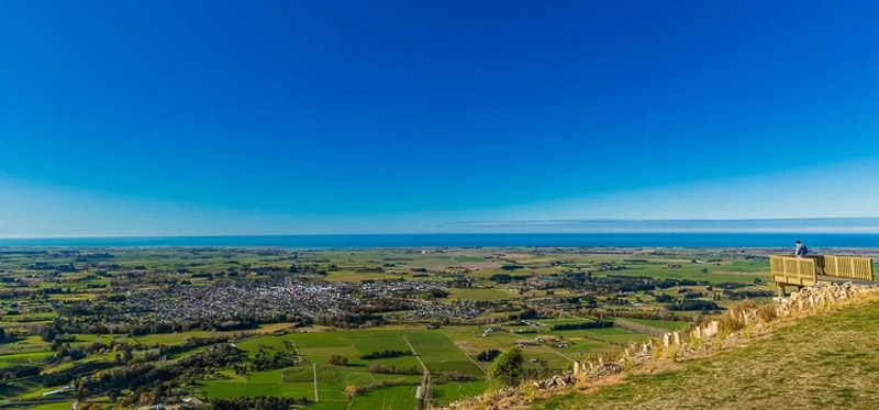
This track climbs to Centrewood Park, home of the white horse. It passes through Point Bush Ecosanctuary, where pest control has helped native forest regenerate and birdlife return, before emerging onto open hilltop grasslands with views stretching from the Pacific Ocean to the Southern Alps.
At the top you’ll find viewing platforms, a picnic area, information boards, pou and toilets. Check the Whitehorse Tracks and Trails map signage to plan your return – head back the same way, take a shared-use trail back to the lower carpark or, cross over into Studholme Bush Reserve. Learn more on The Waimate app.
Location: 228 Point Bush Road. Starting point is Whitehorse Monument Reserve.
Trail difficulty: Moderately steep in places, climbing from 145m to 400m.
Usage: Walking/running.
Time/distance: 2.7km, 2 hours return.
Dogs: No, sorry.
____________
Dashing Rocks Coastal Walk, Timaru
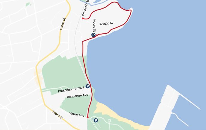
Experience the beauty of Timaru’s coastline, enjoying panoramic views over Caroline Bay, wandering over ancient lava flows and examining the rocky cliffs that proved treacherous to early shipping.
Set off on this loop walk from beautiful Caroline Bay, wander the Benvenue Cliffs past the historic Blackett’s Lighthouse, and the site of ancient shipwrecks.
You’ll turn right up Climie Terrace and along more cliffs where waves crash noisily onto two-million-year-old lava from Mount Horrible. The track takes you from the beach to Westcott Street, and back down Richmond Street to rejoin the coastal stretch back toward Blackett’s Lighthouse.
Just before the lighthouse, cross the footbridge over to Benvenue Ave, wander past Caroline Bay Aquatic Centre, then back down Virtue Ave to your starting point at Caroline Bay.
For more trails in the region, download the Timaru Trails App at visittimaru.nz.
Location: Located in the heart of the city, this walk is easy to find. Make your way to Caroline Bay and follow the signs.
Time/distance: 2.2km, 30 mins.
Difficulty: Easy and gradual.
Dogs: Welcome on lead.
____________
For more information about South Canterbury walks, see waimate.org.nz, geraldinesculpturetrail.nz, southcanterbury.org.nz, mackenzienz.com, and visittimaru.nz.
Source URL: https://metropol.co.nz/winter-walks-south-canterbury/